The Skywalk and the viewpoints on the way up
The road from Geiranger to the top of Dalsnibba starts beside the fjord and ends among snow patches. Between them sit a gorge viewpoint and a lake that stays frozen into summer, and most tours add Eagle Bend on the far side of the valley. This guide takes the stops in turn and shows which tour visits each one.
The Skywalk at the top
The Geiranger Skywalk is a viewing platform with a glass railing at the top of Dalsnibba, marketed at an altitude of about 1,500 m (4,921 ft). The summit itself reaches 1,476 m (4,843 ft). The platform opened in August 2016 and looks over a drop of several hundred meters. Far below, Geiranger sits about 7 km (4 miles) away in a straight line, and the fjord runs off from the village as a thin strip of water. On a clear day the Blåbreen glacier shows up as well.
Only the railing is glass. The floor is solid, so you can walk to the edge or stay a few steps back and still see the valley. When several coaches arrive together the railing fills up, and a few minutes of patience usually opens a gap. Our guide for nervous travelers describes how the platform feels if drops worry you.
What else is at the summit
A building at the top holds a café and a shop selling wool sweaters and souvenirs. Toilets are available too. The café and shop open at 9:30 am. From June 15 to August 14 they close at 6 pm, and for the rest of the season at 5 pm. The summit is often in cloud, and it tends to be around 18 °F (10 °C) colder than the quay, with snow possible in any month. Weather and fog explains your chances of a view, and what to wear covers layers for the top.
From the village to the top
Dalsnibba stands at the end of the Geiranger valley, and the road up from the fjord covers about 21 km (13 miles). It leaves the village in a series of bends, and Flydalsjuvet comes first, a short way above the rooftops. Higher up, the road levels out beside Djupvatnet, where the toll road to the summit turns off. Eagle Bend is not on this road at all. It sits on the opposite slope, so a tour that covers both passes back through Geiranger in between, which is part of why the longer tours take 3 hours or more.
Nibbevegen, the last 5 km
The final climb follows Nibbevegen, a private toll road of about 5 km (3 miles) that leaves the main road at Djupvatnet, around 1,030 m (3,379 ft) up. It winds to the top through 11 hairpins on a 10% grade. The road was finished in 1939, but the Second World War held back its opening until 1948, and it was paved in 2013. Snow often lines it even in summer. Winter shuts it, and the plows usually have it clear for an opening in the second half of May; the season guide sets out the months. Drivers pay at a barrier, and the price guide lists the toll.
Flydalsjuvet and the Queen's Chair
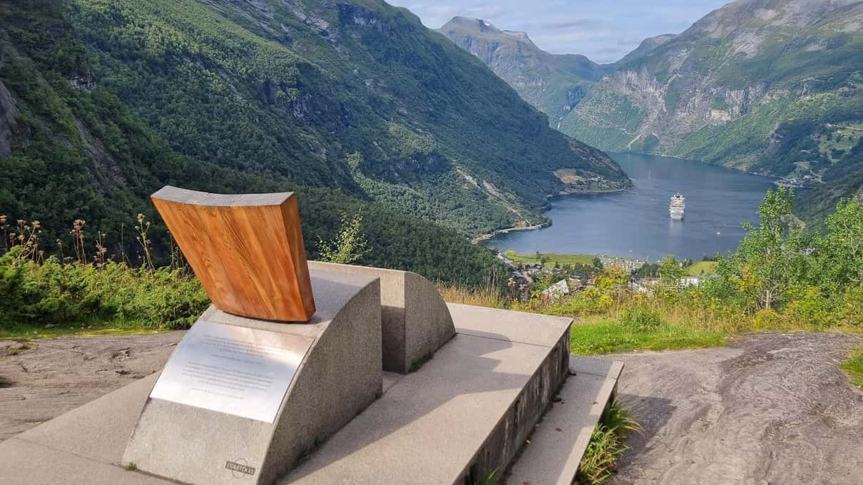
Flydalsjuvet is a gorge viewpoint above Geiranger and one of the most photographed views in Norway. From the railing you look straight down the valley to the village and out along the Geirangerfjord, part of a UNESCO World Heritage site since 2005 together with the Nærøyfjord. On the lower platform stands the Queen's Chair, a seat facing the fjord that draws a queue of people waiting for their photo. Our photo guide has tips for that shot.
Every tour on this site stops here. Your Shore Time allows about 30 minutes, and the panorama bus uses it as a free toilet stop from mid-May to mid-September.
Djupvatnet, the lake below the summit
Above Flydalsjuvet the main road climbs to Djupvatnet, a mountain lake at about 1,000 m (3,281 ft) that stays icy for much of the year, with the Djupvasshytta lodge on its shore. Our pick and the Your Shore Time tour both stop here. The private Calm Giant Tour day goes further and includes a walk along the shore. When early snow and ice closed the summit, some Excursions.no groups spent extra time at the lakes instead.
Every stop on one coach
The 3.5-hour Excursions.no tour from ~$115 visits Flydalsjuvet, the Skywalk, Djupvatnet and Eagle Bend with a live guide, toll included.
Eagle Bend and the Seven Sisters
The Eagle Road, Ørnevegen in Norwegian, leaves the village heading north and climbs through 11 hairpin bends. Near the top, the Eagle Bend viewpoint (Ørnesvingen) looks back over the village and the fjord, and across the water you can pick out the Seven Sisters waterfall. On the shorter panorama bus this is the high point of the trip in place of Dalsnibba.
The Seven Sisters is one of the well-known waterfalls of the Geirangerfjord. The Suitor faces it from the opposite shore, and the Bridal Veil completes the famous set. How much water the Sisters carry depends on the snowmelt, so the strands look fullest in early summer and thinner after a dry spell. From Eagle Bend they read as white threads on a dark cliff, small but clear on a bright day.
Which tour stops where
| Stop | Excursions.no | Bus, 2 h | Bus, 1.5 h | Your Shore Time | Calm Giant Tour |
|---|---|---|---|---|---|
| Flydalsjuvet | Yes | Yes | Yes | About 30 min | Yes |
| Dalsnibba Skywalk | Yes, weather permitting | Yes | No | Yes | Yes |
| Djupvatnet | Yes | Drives past | No | Yes | Lakeside walk |
| Eagle Road and Eagle Bend | Yes | No | Yes | Yes, with the Seven Sisters view | Eagle Road |
Our pick, the Excursions.no tour from ~$115, and the small group tour from ~$122 cover the full set when the summit road is open. The panorama bus from ~$71 splits the route in two, so pick the version that includes the stop you care about. The private tour from ~$1,882 adds a hike toward a waterfall. Which tour to choose compares them in depth, and our cruise guide shows how each one fits a port day.